The above is an image map, use it to navigate the site. Best viewed at 1280 x 1024 using any browser.
Quoich Power Station
OS Grid Ref: NH 10717 01186
Photo: Quoich Surge Shaft The shaft enclosure: Photo by: Mike Ross Looking down the shaft. No access ladder, just a view down the upper expansion
chamber, then the 'rim' around the narrower main part of the surge shaft.
The white substance in the picture is snow. Look carefully and you can
just see the ripples on the water surface, a long way down the shaft -
the water level in the shaft is the same as the level at Loch Quoich, of
course, and that was quite low when this photo was taken: Photo by: Mike Ross Looking down the shaft. No access ladder, just a view down the upper expansion
chamber, then the 'rim' around the narrower main part of the surge shaft.
The white substance in the picture is snow. Look carefully and you can
just see the ripples on the water surface, a long way down the shaft -
the water level in the shaft is the same as the level at Loch Quoich, of
course, and that was quite low when this photo was taken: Illustration by: Scanned by Mike Ross, from Water Power, June 1959 A short distance down the hill below the surge shaft is the construction
adit, used in the building of the tunnel, and still used for access for
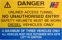
maintenance and inspection: Photo: Quoich Surge Shaft - Adit A closer view of the adit entrance. the sign warns that it's an 'unlined
access tunnel': Photo by: Mike Ross Home Page Last updated 6th May 2006 Style © 1998-2001 Subterranea Britannica Words and images © 2006 Michael J. Ross
|